

Application of the 5D SmartES Platform in Smart City
Written by Ren-Zuo Wang, Chih-Shian Chen, Chih-Yih Hsieh, Chia-Chan Hsu, Fu-Yao Ko, and Jui-Mien Lin
Ensuring operational sustainability during an earthquake is necessary to realize a sustainable smart city. 5D is a smart digital space. The 5D SmartES platform is thus introduced with the primary objective of intelligent decision making. This platform integrates the digital space with dynamic and static data, establishes the relationship between a three-dimensional (3D) model and its surroundings, overlays actual scenes with the real world, and interacts with 3D models. This platform was used in Shalun Smart Green Energy Science City (SSGES-City) Zone C for indoor environmental monitoring and power consumption information.
Introduction of the 5D SmartES Platform
A smart city is a technologically modern urban area that integrates communication technology and the Internet of Things (IoT) in a secure way to manage urban systems in order to minimize the resources consumed and maximize the quality of life, health of the citizens, and human governance [1,2]. Since Taiwan experiences frequent earthquakes and is a high seismic hazard, ensuring operational sustainability to realize a sustainable smart city is necessary during an earthquake. Therefore, the National Center for Research on Earthquake Engineering (NCREE) has developed a 5D smart earth simulation platform named 5D SmartES that is used for 5D smart cities. This platform is a combination of a building information modeling (BIM) (building, facility, etc.), Taiwan satellite imagery, and a digital elevation model (DEM). A three-dimensional (3D) geographic information system (GIS) consists of Taiwan satellite imagery and DEM. Time information from IoT is called 4D, which is transmitted through sensors to send digital information. 5D is a smart digital space that includes (1) a combination of 3D static model and static data, (2) a combination of dynamic 3D models and dynamic data, and (3) a combination of static and dynamic model and artificial intelligence, finite element method, structural dynamic analysis, etc. This platform is established based on all static and dynamic data with 3D GIS. Therefore, it can be used for intelligent decision making. The smart digital space (5D) becomes the digital twin of the real world through 4G, 5G, and 6G, which can shorten synchronization of 5D and real-world information [3]. This platform can display the city's fine triangular mesh model established by large-scale aerial photography. It can display a fine triangular mesh model of more than twenty square kilometers. The total number of triangular meshes is more than 64 million. This platform has potential applications to many fields, such as smart power monitoring (Fig. 1), intelligent monitoring (Fig. 2), rapid detection of disasters (Fig. 3), security command center (Fig. 4), and automated crack detection on concrete bridges.
|
Figure 1: Smart power monitoring. |
|
|
Figure 3: Rapid detection of disasters. |
Figure 4: Security command center. |


BIM integrates and stores relevant data for each stage for the entire life cycle of a building in a 3D model [4]. BIM uses the concept of object-oriented programming languages to store, share, and use information more efficiently. Moreover, BIM produces new commercial supply-chain system modes through consistent information delivery. With the development of BIM, the traditional process flow of the construction is changed in the future. GIS are computer and software tools that catch, oversee, dissect, and show all types of geologic referenced data. GIS enables a city to view, question, and comprehend information from multiple points of view [5].
The framework of 5D SmartES platform is shown in Fig. 5. This platform has many functions, including:
- Integrated development environment: Users can intuitively observe relationships between the location of devices, information, and nearby geographical conditions.
- Real-time interactive operation: Users can use input interfaces such as a keyboard and mouse to interact with the platform, display characteristics at any angle in the 3D scene, and improve the convenience of data access.
- Multiple projection display methods: The platform can support curved projection, VR, and 3D stereo vision projection to provide more diverse visual experience effects.

Figure 5: Framework of the 5D SmartES platform.
Example of an Integrated Application of a 5D SmartES Platform in Building Information Modeling: Shalun Smart Green Energy Science City Zone C

Figure 6: Integration of the BIM 3D model in Taiwan SSGES-City Zone C.
Shalun Smart Green Energy Science City (SSGES-City) Zone C is an application field for the development of smart green energy technology (Fig. 6). The goal is to build a smart grid in Zone C, integrate renewable energy, and develop smart control and energy management technologies. The smart grid is based on the concept of hierarchy (Fig. 7). The ascending management system is connected layer by layer. The smallest unit is the Home Energy Management System (HEMS), whose unit is at the family level. The larger system is the Building Energy Management System (BEMS), which can manage an entire building. When the scope is expanded, the Community Energy Management System (CEMS) is required to manage many BEMSs. The CEMS database integrates information such as solar power generation, electricity consumption, and environmental monitoring. After the 5D SmartES platform captures the relevant information from the database, it is integrated with BIM to develop applications for integration and development.
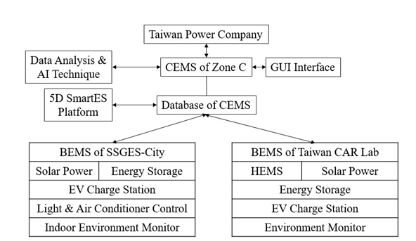
Figure 7: CEMS architecture diagram of SSGES-City Zone C.
Various factors such as temperature, humidity, CO concentration, CO2 concentration, brightness, surveillance images have an important impact on building maintenance. This platform makes it easier for users to check the locations and monitoring data of sensors. Below are the practical applications of this platform.
Indoor Environmental Monitoring

Figure 8: Indoor environmental monitoring information display.
The indoor environment monitoring items include temperature, humidity, illuminance, CO, and CO2. Function setting is performed such as adjusting the air-conditioning temperature through infrared controllers automatically. The monitoring data is displayed next to the sensor installation location, which establishes the correspondence between information and space.
Power Consumption Information

Figure 9: Indoor monitoring information display.
The total power consumption of the building, power consumption of each space, and power consumption of single air-conditioning units are displayed by collecting the monitoring data of smart meters. The relevant information is used to analyze the proportion of each space's power consumption to total power consumption and evaluate future electricity demand and cost.
Conclusion
This paper introduces the concept of 5D for smart cities and has successfully developed 5D SmartES platform for intelligent decision making. SSGES-City Zone C is an application field for the development of smart green energy technology. This platform is different from other platforms for the following reasons:
- This platform integrates the digital space with the dynamic and static data, which is used as the digital twin of the real world.
- This platform establishes the relationship between 3D model and surroundings in order to facilitate decision makers to make effective and rational decisions.
- This platform overlays actual scene with the real world, which is helpful to position the 3D models rapidly.
- This platform can interact with 3D models.
References
- Kim, B., S. Kang, J. Y. Ha, and S. Kang. (2015). “Agatha: Predicting Daily Activities from Place Visit History for Activity-Aware Mobile Services in Smart Cities.” International Journal of Distributed Sensor Networks:1-12. https://doi.org/10.1155/2015/867602
- Bawany, N. Z. and J. A. Shamsi. (2015). “Smart City Architecture: Vision and Challenges.” International Journal of Advanced Computer Science and Applications 6 (11):246-55. 10.14569/IJACSA.2015.061132
- Ferré-Bigorra, J., M. Casals, and M. Gangolells. (2022). “The adoption of urban digital twins.” Cities 131:103905. https://doi.org/10.1016/j.cities.2022.103905
- Xia, H., Z. Liu, M. Efremochkina, X. Liu, and C. Lin. (2022). “Study on city digital twin technologies for sustainable smart city design: A review and bibliometric analysis of geographic information systems and building information modeling integration.” Sustainable Cities and Society 84:104009. https://doi.org/10.1016/j.scs.2022.104009
- Marzouk, M. and A. Othman. (2020). “Planning utility infrastructure requirements for smart cities using the integration between BIM and GIS.” Sustainable Cities and Society 57:102120. https://doi.org/10.1016/j.scs.2020.102120
To view all articles in this issue, please go to November 2022 eNewsletter. For a downloadable copy, please visit the IEEE Smart Cities Resource Center.


To have the eNewsletter delivered monthly to your inbox, join the IEEE Smart Cities Community.
Past Issues
To view archived articles, and issues, which deliver rich insight into the forces shaping the future of the smart cities. Older eNewsletter can be found here. To download full issues, visit the publications section of the IEEE Smart Cities Resource Center.
IEEE Smart Cities Newsletter Editors

Managing Editor

Assistant Managing Editor
IEEE Smart Cities Publications Editorial Board
Luis M. Fernandez-Ramirez
Bernard Fong
Sergii Kushch
Prasad Enjeti
Rabie Ramadan
Ramkumar Lakshminarayanan
Francesco Flammini
Fateh Krim
Maria Pia Fanti
Kristina Kunert
Vladimir Orlic
Asif Ali Ahmed R
Werbeston Oliveira
Emilio Ghiani
Shafi Khadem
Nikumani Choudhury
Mohammad Zeyad
S.M. Masum Ahmed
Payman Dehghanian
Sona N Thadevus
Kumaresan Natarajan
Lues Felipe Gaitan Cubides
Chao Shen
Balaji Sankarshanan
Chun Sing Lai
Zhang Wei
Shashikant Patil
Sai Munikoti
Akhil Jabbar Meerja
Click here for more info
Loi Lei Lai
Editor-in-Chief
IEEE Smart Cities eNewsletter