

Eye in the 5G Sky for Smart Cities
Written by Sathiyakeerthi M
In the coming years, the promising concept of smart cities is going to completely revolutionize human lives. Its technological advancements are making their way to improve the current transportation systems, homes, healthcare departments, energy, secure building infrastructures, farming and much more, making them smarter than ever. What is even a better addition to this is the introduction of drones in smart cities as an aid to enhance the lives of citizens and speed up the service delivery process. Drones are basically the unmanned aerial vehicles that move from one point to another autonomously, via software-controlled flight plans, providing coverage as well as performing key operations such as monitoring, surveillance, management, etc. This cutting-edge technology offers immense applications due to its cost-effective service provision and efficiency [1].
In Smart Cities, drones are expected to play numerous roles such as in medical care, package delivery, police operations, traffic monitoring, signal coverage, relaying, disaster management, agricultural operations, security, firefighting and many more [2-4]. The 5G network, as the latest wireless communication technology featuring ultra-high speed, super low latency, and massive connectivity, is bound to have a profound impact on smart cities [5][6]. With high bandwidth, 5G supports ultra-high-definition video transmission with low latency, which comes in handy during the remote control of drones in emergency situations. A majority of drones have currently their communication encrypted and are controlled via Wi-Fi, but 5G will allow them to fly to a much larger area, while being less susceptible to hacker interference. Hence, the integration of 5G characteristics in modern drones will be a remarkable achievement towards turning the idea of an ideal smart city into reality [7-9].
5G Camera-Drone Applications
In the retail industry, the adoption of drones is increasing day-by-day due to the increase in online ordering process in areas having dense population. This integration would help the retailers to meet the “11th hour” order deliveries efficiently. The recent lockdown situation due to COVID-19 has been a critical time for people across the world, who could not go out and buy essential items for their household. In such times, the Google’s “Project Wing” emerged as the most helpful drone delivery service system to deliver essentials such as medicine, toilet papers, food, baby items, etc., for people living in Virginia, USA [10]. These drones were able to carry parcels weighing up to 1.3Kgs for a distance of 12 miles. Moreover, in China, drones were used to disinfect hospitals, streets and public areas, and maintain quarantine restrictions against corona virus [11]. Officials directed the citizens to remain inside and supervised them remotely during the pandemic via a drone with loud-speakers for conveying orders. Furthermore, the drones were also able to detect people with fevers from air by using thermal imaging.
A Danish consulting engineering company, named COWI, employs drones for gathering geographical data for its various projects. COWI is also one of the first companies to use drones for monitoring traffic flow in Denmark. According to its drone and data specialist, Annika Debes, drones are also used for the maintenance of the Oresund Bridge where camera drones take pictures and measurement data of the bridge [12].
Drones are also being employed in police department of the smart cities where they are used for criminal tracking [13]. In China, about 1000 drones have been made part of the police department for tracking criminals and locating opium farms suspects till 2017 [14]. In England and Wales, a large number of forces are considering using drones for investigation of criminals [15].
As it becomes evident, drones are gradually being introduced in almost all fields of smart cities from pollution control centers to self-driven taxi drones, to firefighting and rescue drones etc., in order to improve the quality of life.
HD Camera-Based Drone with 5G Architecture
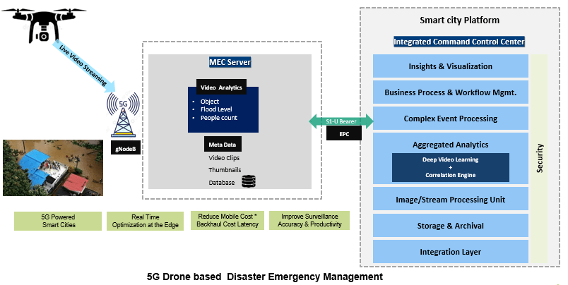
Drones can play an important role in disaster management. In the figure shown below, the working of a drone in a 5G network is explained during disaster management in a smart city. A 5G drone, connected to a Next Generation Node B (gNB), provides a live streaming of the disaster struck area. The Next Generation Node B (gNB) is a complex base station that manages radio communication with multiple devices simultaneously and perform radio resource management and handover decisions in the network. The Mobile Edge Computing (MEC) server (also referred to as Multi-access Edge computing that offers cloud-computing capabilities to the content providers and developers that lie close to the end users) uses video analytics to analyze images from the area, including the objects present, the level of the flood and the number of people in danger, which is then sent to the Integrated Command Control Center of the smart city platform that directs the drone remotely to the position for data gathering. Upon this gathered information, the smart city officials take further actions to rescue the people from the disaster area and keep a constant check over the situation. This is how a drone works in a 5G network during disaster management.
5G Features to Address Current Challenges
The upcoming 5G network is based on the vision of providing very high data rates of 1-10Gbps, wider coverage area, enhanced throughput, delay-less services, round trip latency of 1 ms, availability of 99.999%, and a significantly better Quality-of-Services (QoS) than 4G. It is not just a next generation of 4G networks but is much more beyond that in terms of technological capabilities and service provisioning. Listed below are some of the features of 5G networks [16]:
- Ultra-reliable low-latency communication (uRLLC)
- Massive machine-type communication (mMTC)
- Enhanced mobile broadband (eMBB)
- Network slicing
- Multi-access edge computing (MEC)
These 5 features are the key technologies of 5G networks, which will not only enhance the performance but also mitigate the challenges of higher user demands, latency, security, low edge services, limited resources etc., that are being faced in the current 4G network.
Key Performance Indicators (KPIs)
The key performance indicators (KPIs) are parameters that show the requirements of a system or a network that should be maintained in order to get the desired performance from the network. Given below is the list of KPIs that is required for the successful deployment and operation of 5G drone applications [17]:
- Latency: The time taken to transfer the data from source to destination. It is measured in ms, at the communication interface.
- Packet Loss: The percentage of frames that should have reached the destination but failed to be forwarded by the network.
- Bit Error Rate: The ratio of the number of bit errors to the total number of transferred bits during an observed time interval.
- Energy Efficiency: The measure of 1 Joule of energy consumed during the transfer of one byte from source to receiver.
- Security: The level of precautionary measures taken to prevent an attack.
- Data Rate (DL/UL): The number of bits transferred during 1 second. It is the minimum data rate required to achieve a sufficient quality of experience (QoE).
- Jitter: The short-term variations in the instances of a digital signal from their ideal positions in time.
- Packet Delay Variation: The variation in latency of a packet observed during a particular time across a network.
- Reliability: The percentage of the number of network layer packets delivered successfully to a node in a given time, divided by the total sent network layer packets.
- Availability: The percentage of the amount of time the communication service is delivered from sender to receiver with the desired QoS, divided by the time the system is expected to deliver the service as per the specifications.
- Mobility: The fixed or maximum speed n movement.
- Traffic Density: The traffic in a specific area.
- Connection Density: The number of devices connected in a specific area.
- Coverage: The area of service availability.
- Battery Life: The duration of a battery in terms of time.
- Data Size: The size of the frame or atomic packet.
Conclusion
5G based drones are considered as one of the leading technologies that will completely evolve the image of smart cities. The camera drones will not only enhance the performance of the network but will also perform human tasks quickly with cost-effective services. However, in order to practically implement this idea, it is necessary to fulfill the performance requirements of the network so that drones can improve each aspect of human life with its innumerous astounding applications.
References:
- 3GPP TS 22.125 “Unmanned Aerial System (UAS) support in 3GPP”, https://www.3gpp.org/ftp/Specs/archive/22_series/22.125/
- N. Dilshad, J. Hwang, J. Song and N. Sung, "Applications and Challenges in Video Surveillance via Drone: A Brief Survey," 2020 International Conference on Information and Communication Technology Convergence (ICTC), 2020, pp. 728-732, doi: 10.1109/ICTC49870.2020.9289536.
- R. K. Rangel, J. L. Freitas and T. M. de Souza, "Smart & Integrated Management System - Smart Cities, Epidemiological Control Tool Using Drones," 2020 IEEE Aerospace Conference, 2020, pp. 1-12, doi: 10.1109/AERO47225.2020.9172439.A. Giyenko and Y. I. Cho, "Intelligent.
- Unmanned Aerial Vehicle Platform for Smart Cities," 2016 Joint 8th International Conference on Soft Computing and Intelligent Systems (SCIS) and 17th International Symposium on Advanced Intelligent Systems (ISIS), 2016, pp. 729-733, doi: 10.1109/SCIS-ISIS.2016.0159.
- P. Zhang, X. Yang, J. Chen and Y. Huang, "A survey of testing for 5G: Solutions, opportunities, and challenges," in China Communications, vol. 16, no. 1, pp. 69-85, Jan. 2019.
- M. Agiwal, A. Roy and N. Saxena, "Next Generation 5G Wireless Networks: A Comprehensive Survey," in IEEE Communications Surveys & Tutorials, vol. 18, no. 3, pp. 1617-1655, thirdquarter 2016, doi: 10.1109/COMST.2016.2532458.
- 5G smart cities whitepaper https://www2.deloitte.com/content/dam/Deloitte/cn/Documents/technology-media-telecommunications/deloitte-cn-tmt-empowering-smart-cities-with-5g-white-paper-en-200702.pdf
- 3GPP Status Report to TSG, RAN2 UAV Requirements, R2-1706013_LS on UAV requirements.doc
- 3GPPTR22.829 “Enhancement for Unmanned Aerial vehicles” https://portal.3gpp.org/ngppapp/CreateTdoc.aspx?mode=view&contributionId=951035
- India Block, “Google’s Wing Drone Deliver Essentials During Coronavirus Pandemic”, 15 April 2002, [Available at]: https://www.dezeen.com/2020/04/15/google-wing-drone-delivery-coronavirus-virginia/
- India Block, “Drones and Self-Driving Robots Used to Fight Coronavirus in China”, 20 February 2020, [Available at]: https://www.dezeen.com/2020/02/20/drones-robots-coronavirus-china-technology/
- Annika Debes Vestergaard, Drone and Data Specialist, “The Drone Whisperer”, [Available at]: https://www.cowi.com/ingenord/the-drone-whisperer
- Jason Reagan, “Police Drones Unleashed in China”, 28 Jan 2016, [Available at]: https://dronelife.com/2016/01/28/police-drones-unleashed-in-china/
- Zhao Lei, China Daily, “1000 Drones Used by Police Across Country”, 19 June 2017, [Available at]: https://www.chinadaily.com.cn/china/2017-06/19/content_29792454.htm
- BBC News Services, “North Wales Police Use Drones to Fight Crime”, 10 Jan 2018, [Available at]: https://www.bbc.com/news/uk-wales-42636797
- A. Ghosh, A. Maeder, M. Baker and D. Chandramouli, "5G Evolution: A View on 5G Cellular Technology Beyond 3GPP Release 15," in IEEE Access, vol. 7, pp. 127639-127651, 2019, doi: 10.1109/ACCESS.2019.2939938.
- D1.1–Use case specifications and requirements https://5gdrones.eu/wp-content/uploads/2020/05/D1.1-Use-case-specifications-and-requirements-v1.0.pdf
This article was edited by Aris Gkoulalas-Divanis
For a downloadable copy of the September 2021 eNewsletter which includes this article, please visit the IEEE Smart Cities Resource Center.

To have the eNewsletter delivered monthly to your inbox, join the IEEE Smart Cities Community.
Past Issues
To view archived articles, and issues, which deliver rich insight into the forces shaping the future of the smart cities. Older eNewsletter can be found here. To download full issues, visit the publications section of the IEEE Smart Cities Resource Center.
IEEE Smart Cities Newsletter Editors

Managing Editor

Assistant Managing Editor
IEEE Smart Cities Publications Editorial Board
Luis M. Fernandez-Ramirez
Bernard Fong
Sergii Kushch
Prasad Enjeti
Rabie Ramadan
Ramkumar Lakshminarayanan
Francesco Flammini
Fateh Krim
Maria Pia Fanti
Kristina Kunert
Vladimir Orlic
Asif Ali Ahmed R
Werbeston Oliveira
Emilio Ghiani
Shafi Khadem
Nikumani Choudhury
Mohammad Zeyad
S.M. Masum Ahmed
Payman Dehghanian
Sona N Thadevus
Kumaresan Natarajan
Lues Felipe Gaitan Cubides
Chao Shen
Balaji Sankarshanan
Chun Sing Lai
Zhang Wei
Shashikant Patil
Sai Munikoti
Akhil Jabbar Meerja
Click here for more info
Loi Lei Lai
Editor-in-Chief
IEEE Smart Cities eNewsletter