

LoRaWAN as a Cost-Effective Technology for Assets Localization in Smart Harbors
Written by Azin Moradbeikie1,2, Ahmad Keshavarz1, Habib Rostami1, Sara Paiva2, and Sergio Ivan Lopes2,3
According to the United Nations, nowadays, 55% of the world's population lives in cities, with that percentage predicted to rise to 68% by 2050 [1]. This increase will lead to fundamental social, economic, and environmental challenges that will shape the way we experience cities. Moreover, due to its complexity, a city can be seen as a system composed of different sub-systems like transportation, logistics, power grids, factories, harbors, etc., that interact and function as a whole. The 2030 United Nations Agenda for Sustainable Development points out industrialization, i.e. Industry 4.0, as a fundamental driver to increase productivity, value, and job creation. Moreover, to achieve these industrial development goals, Industrial Internet of Things (IIoT) technologies emerge as key enablers that pave the way to inclusive and sustainable industrial development sustained by improving processes in continuous innovation cycles. As a result, each sub-system of the city should become smarter, not only by collecting more data, but also, by giving meaning to data, in both spatio-temporal dimensions. The spatial context of data is therefore relevant and transversal in some city sub-systems, such as transportation and logistics, where, for example, harbors play a vital role, due to their vital relevance on the industrial and manufacturing supply chains.
A harbor is composed of several important parts (terminal, query, and yard) and devices (quay cranes and terminal tractors) [2][3]. Figure 1 shows the important parts of a harbor. When a vessel arrives at the harbor, the Terminal Management System (TMS) --- the brain of a smart harbor --- determines which specific terminal should be used to anchor. Each terminal can contain several queries. The query is the place that containers are unloaded from the vessel. Then, several quay cranes start working to unload containers from vessel to terminal tractors. Terminal tractors move the containers from the query to the yard. The yard is a temporary storage area for containers. Finally, containers are transferred to the train or airport for transporting.
The TMS manages different tasks, which include localization of vessels, tractors, and containers, controlling quay cranes for unloading containers from vessels to tractors, directing tractors from vessels' sides to a yard, etc. With the continuous growth of vessels size due to economic reasons, the management of harbors is becoming more and more complex. Therefore, a smart harbor adopts new technologies such as communication technologies, cloud computing, advanced robotics, intelligent machines, etc., to enhance the harbor activities and improve the performance of existing services. According to the World Shipping Council report, China is a pioneer in the development of smart harbors.
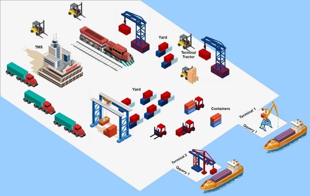
Figure 1: Important harbor infrastructures.
Statement of the Challenge
A smart harbor needs robust and reliable localization and tracking methods to locate and manage available assets, such as vessels, containers, tractors, etc. Using appropriate positioning systems and location-based services can lead to a more efficient harbor management by supporting decision-making. To reach this purpose, Location-Enabled IoT Tags (LE-IoTT) become a suitable and affordable answer [4].
LE-IoTTs are low-cost IoT tags specifically designed to provide location context to harbor assets. Based on the large areas of terminals and the large number of assets involved, the adopted positioning techniques should be suitable to work in wide areas and needs to be low-cost, because the number of LE-IoTT tends to increase exponentially, and to perform effective asset management in the harbor, such LE-IoTT present several physical constraints that should be taken into account, such as, size (tag with antenna), autonomy (battery-less), robustness (shock resistant), waterproof, etc., and specifically, radio chipsets operating in license-free bands, that should be cost-effective and present low-power consumption.
GNSS-based localization technologies (GPS (U.S.), GLONASS58 (Russia), Beidou (China), and Galileo (E.U.)), present some drawbacks that include high cost, high power consumption, and low efficiency in indoor environments. In addition, GNSS-based systems provide location information only for the IoT device itself. For these purposes, researchers have been developing novel positioning methods that rely on Low Power Wide Area Network (LPWAN) standards, which are typically used in low-power long-range IoT/IIoT application domains.
LPWAN is the most accepted technology for providing communication and localization simultaneously in a smart harbor [5][6]. Between different LPWAN technologies (e.g., LoRaWAN, Sigfox, and NB-IoT), distinct factors like battery life, cost efficiency, range, and latency performance make LoRaWAN more suitable for the specific application case of smart harbors (it operates in license free band and allow private network deployment).
LoRaWAN is composed of three important parts: LoRa end nodes, LoRa gateways, and the LoRa network server [7]. The LoRa end nodes correspond to the LE-IoTT that will be attached to assets in the harbor. The LoRa-based LE-IoTT sent data to LoRa gateways, which then sends the received data from the end node with received signal features to the LoRa network server. The LoRa network server estimates the location of the end node based on received signal features. Received Signal Strength Indicator (RSSI), Time-of-Arrival (ToA), Time-Difference-of-Arrival (TDoA), and Angle-of-Arrival (AoA) are the commonly used methods for wireless localization.
ToA, TDoA, and AoA need additional hardware and accurate time synchronization that makes them expensive for the smart harbor application case because of its crowded and dynamic environment. Therefore, RSSI-based methods, due to their simplicity, low-cost, and suitable accuracy, have been recently adopted for harbor assets localization and management. Distance estimation of the LoRa-based LE-IoTT from LoRa gateway can be computed by Equation 1 [8],

Where n is the path loss exponent, A is the RSSI value at a reference distance from the receiver and d is the distance between a LoRa-based LE-IoTT and the LoRa gateway. On the other hand, RSSI-based methods are affected by interference and multi-path fading (reflection, scattering, and diffraction). The performance of RSSI-based localization to a large extent is determined by the behavior of wireless channels and on the propagation environment in which the communication is taking place.
Harbors are characterized as a wide area with a harsh environment with a multitude of metallic components and surfaces, and, as harbors are near to the sea, the fading effect will increase. Therefore, the successful localization method of a wireless communication system relies on the proper understanding of channel characteristics and their subsequent impact on the communication signal. Environmental factors, like the weather, are constantly changing, being one of the most important error sources that negatively impact the radio signals used for communication, leading to an increase in the location estimation error [9].
Technological Innovation
Over time the harbor can experience different weather conditions (e.g., rain, snow, fog, etc.) that affect the transmitted signals (forcing a power fluctuation at the reception), which considerably impacts the overall localization performance of such systems. For increasing the localization estimation accuracy, it is important to determine the environmental effects on the different factors of the signal. On the other hand, harbors have large areas and distinct LoRaWAN gateways can be settled within large areas and experience specific weather situations at the same time. Therefore, each gateway should evaluate the received signals based on its specific condition.
For this purpose, each gateway may be equipped with sensors to measure environmental parameters, such as temperature, relative humidity, etc. The adopted sensors can be used for weather feature selection and therefore used to predict the environmental effect on power fluctuation of signals. Correct power fluctuation prediction leads to a location estimation accuracy improvement.
In addition, each GW may be settled in a different sub-urban/rural outdoor environment surrounded by buildings, roads, trees, sea, etc. Various outdoor environments lead to different interference and multi-path fading. For interference and multi-path fading effect prediction in a signal, a specific IoT device can be used as a channel reference. For this purpose, the IoT-based channel reference is deployed in a predetermined location to periodically transmit data that will be gathered by surrounding GWs. Each GW measures the channel effects on the transmitted signal based on the RSSI and real distance between the IoT-based channel reference and the GW. Figure 2 shows the proposed IoT-based channel reference method for channel effects measurements.
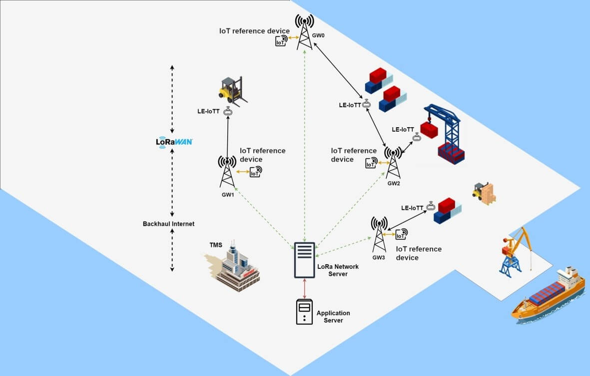
Figure 2: Overall system architecture.
Outlook and Next Steps
In a smart harbor, a scalable and robust communication network for device and asset positioning is an essential requirement. LoRaWAN technology is an appropriate solution for the specific smart harbor application case requirements. To improve the location estimation accuracy in a smart harbor equipped with LoRaWAN technology, it is important to determine the environmental error source that affect each GW and predict their impact on the transmitted signal. The impact of the continuously changing environment in the localization error can be mitigated by a timely and effective prediction of the signal features changes. Equipping the GWs with environmental sensors and deploying IoT-based channel reference nodes seems a promising approach for location estimation improvement.
To achieve these goals, providing Fog and Edge computing as a new computing model for GWs to preprocess the RSSI data, by applying some rules, and interference filtering is a direction to explore.
For this purpose, Edge-AI can provide the required facilities and effectively improve the range measurements. Moreover, by taking advantage of edge computing we are bringing computation and storage to the edge of the network, near to where the data originates yielding reduced network load and better performance of services. Numerical results demonstrated that the proposed method leads to a location estimation improvement of approximately 100 m.
Acknowledgements:
1 PGU - Persian Gulf University, Bandar Bushehr, Iran {amoradbeiki, a.keshavarz, habib}@pgu.ac.ir
2 ADiT-Lab - Instituto Politecnico de Viana do Castelo, Rua Escola Industrial e Comercial Nun Alvares, 4900-347 Viana do Castelo, Portugal. {sil, sara.paiva}@estg.ipvc.pt
3 IT- Instituto de Telecomunicacoes, 3810-193 Aveiro, Portugal
References
- United Nations, Department of Economic and Social Affairs, the Population Division of the United Nations Department of Economic and Social Affairs (UN DESA), (2018).
- X. Fu, Internet of Things for Smart Ports: Technologies and Challenges, (2018). https://doi.org/10.1109/MIM.2018.8278808.
- A. Molavi, G.J. Lim, B. Race, A framework for building a smart port and smart port index, International Journal Sustain. Transp. 0 (2019) 1–13. https://doi.org/10.1080/15568318.2019.1610919.
- Y. Li, Y. Zhung, J. Hu, L. Chen, Z. He, L. Pei, K. Chen, M. Wang, X. Niu, R. Chen, J. Thompson, Toward Location-Enabled IoT ( LE-IoT ): A Survey of Positioning Techniques , Error Sources , and, IEEE Internet of Things Journal, 8 (2020), 4035–4062.
- B.S. Chaudhari, M. Zennaro, LPWAN Technologies: Emerging Application Characteristics, Requirements, and Design Considerations, (2020).
- I.F. Priyanta, F. Golatowski, T. Schulz, D. Timmermann, Evaluation of LoRa Technology for Vehicle and Asset Tracking in Smart Harbors, IECON 2019 - 45th Annu. Conf. IEEE Ind. Electron. Soc. 1 (2019) 4221–4228.
- J. Haxhibeqiri, A Survey of LoRaWAN for IoT: From Technology to Application, (2018). https://doi.org/10.3390/s18113995.
- P. Savazzi, S. Member, E. Goldoni, A. Vizziello, L. Favalli, P. Gamba, A Wiener-based RSSI localization algorithm exploiting modulation diversity in LoRa networks, IEEE Sensors Journal, 19 (2019). https://doi.org/10.1109/JSEN.2019.2936764.
- O. Elijah, V. Sittakul, A.M. Al-samman, M. Cheffena, J.B.I.N. Din, A.R. Tharek, Effect of Weather Condition on LoRa IoT Communication Technology in a Tropical Region: Malaysia, IEEE Access. 9 (2021) 72835–72843. https://doi.org/10.1109/ACCESS.2021.3080317.
This article was edited by Sara Paiva
For a downloadable copy of the October 2021 eNewsletter which includes this article, please visit the IEEE Smart Cities Resource Center.


To have the eNewsletter delivered monthly to your inbox, join the IEEE Smart Cities Community.
Past Issues
To view archived articles, and issues, which deliver rich insight into the forces shaping the future of the smart cities. Older eNewsletter can be found here. To download full issues, visit the publications section of the IEEE Smart Cities Resource Center.
IEEE Smart Cities Newsletter Editors

Managing Editor

Assistant Managing Editor
IEEE Smart Cities Publications Editorial Board
Luis M. Fernandez-Ramirez
Bernard Fong
Sergii Kushch
Prasad Enjeti
Rabie Ramadan
Ramkumar Lakshminarayanan
Francesco Flammini
Fateh Krim
Maria Pia Fanti
Kristina Kunert
Vladimir Orlic
Asif Ali Ahmed R
Werbeston Oliveira
Emilio Ghiani
Shafi Khadem
Nikumani Choudhury
Mohammad Zeyad
S.M. Masum Ahmed
Payman Dehghanian
Sona N Thadevus
Kumaresan Natarajan
Lues Felipe Gaitan Cubides
Chao Shen
Balaji Sankarshanan
Chun Sing Lai
Zhang Wei
Shashikant Patil
Sai Munikoti
Akhil Jabbar Meerja
Click here for more info
Loi Lei Lai
Editor-in-Chief
IEEE Smart Cities eNewsletter